Gunter

Gunter.city — Small town. Big heart. Your neighborhood news.

Back to Weather

5-day forecast / Gunter, TX

SaturdayShowers And Thunderstorms Likely75° / 64° 66%
SundayMostly Sunny81° / 61° 14%
MondaySunny81° / 57°
TuesdaySunny81° / 56°
WednesdaySunny82° / 58°

Gunter Weather: Flood Watch Active Amid Heavy Rain and Thunderstorms - Oct 1, 2 PM

Gunter weather, updated every four hours — local forecasts you can trust.

A severe Flood Watch is in effect for Gunter as heavy rains and thunderstorms continue. Current conditions show 70F with high humidity, and significant rainfall is expected through tomorrow.

Sasha Zimmer

October 1, 20262 min read

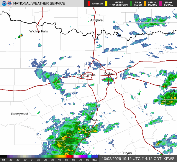
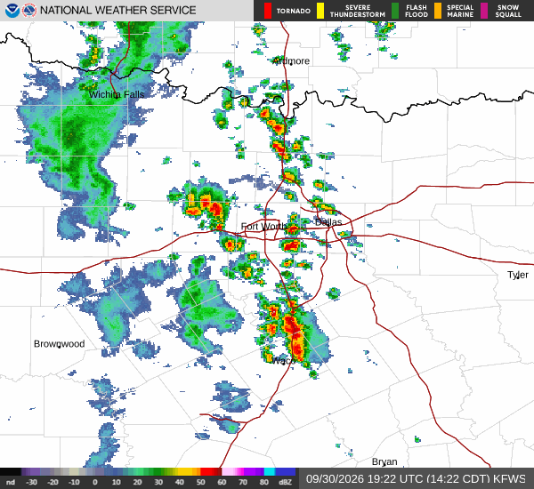
National Weather Service radar for North Texas (KFWS)

*As of Oct 1, 2 PM local time.*

Current Conditions and Immediate Outlook

A severe Flood Watch is currently active for the Gunter area, signaling a heightened risk of flooding due to ongoing and expected heavy rainfall. As of this afternoon, the air temperature stands at 70 degrees Fahrenheit, feeling like 70 degrees. The atmosphere is saturated, with relative humidity at 94 percent and a dew point of 68 degrees.

Winds are blowing from the south southeast at around 10 miles per hour, with gusts reaching 13 miles per hour. The sky is currently obscured by rain and fog or mist, creating low visibility and slick road conditions. Residents should remain vigilant as the weather system continues to move through the region.

Today and Tonight

Showers and thunderstorms are likely to persist before 4 p.m., followed by a continued chance of storms later in the day. The high temperature will hover near 76 degrees. The probability of precipitation is approximately 70 percent, with new rainfall amounts between a tenth and a quarter of an inch possible.

Tonight, the chance of showers and thunderstorms remains high, particularly before 10 p.m., after which storms are expected to continue. The low temperature will be around 69 degrees, though it may rise to 72 degrees overnight. Winds will shift to the southeast at about 5 miles per hour.

The chance of precipitation increases to 80 percent, with significant rainfall amounts between three-quarters and one inch possible. This accumulation is a primary driver for the active flood watch.
Tomorrow and Safety Reminders

Tomorrow will bring continued showers and thunderstorms under cloudy skies. The high temperature is expected to be near 74 degrees, with temperatures falling to around 72 degrees in the afternoon. Winds will shift to the north northeast, ranging from 5 to 10 miles per hour.

The chance of precipitation is 80 percent, with another three-quarters to one inch of rain possible. Given the severe nature of the flood watch, which remains in effect until early tomorrow morning, residents should avoid traveling through low-lying areas or flooded roads. It is crucial to stay informed through official channels and to take precautions to protect property from potential water damage.

Stay safe and monitor local updates throughout the day.

National Weather Service radar for North Texas (KFWS)

Sources

National Weather Service radar

National Weather Service forecast data

Open-Meteo weather data

Share

Sasha Zimmer

Sasha Zimmer covers weather, storms, and seasonal life around Gunter.

Related Stories

More in Sport